
The official arrival of summer in the Poconos kicked off with a beautiful sunset, just one of many that we will see in the next few months, we'd love to see your photos as well! … [Read more...]
Rain and Rainbows in the Poconos
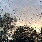
It's been pretty rainy the past few days, here's some photos from earlier this week. … [Read more...]
Spring Is On The Horizon In The Poconos

The warm weather finally arrived this week after a few relentless weeks of winter cold and unending snow. It was in late January that I made this post about "Finally Some Snow in the Poconos", and at the time little did I know that following that storm would be week after week of winter storms. Schools in the Poconos closed quite a few times due to the cold alone, and then … [Read more...]
Finally Some Snow In The Poconos

We have had an extremely disappointing lack of snow in the Poconos so far this winter. There have been dustings and an inch or two of snow here and there, but the only larger accumulating storm was back before Christmas. This morning I woke up to this welcomed sight: It looks like we got about 6 inches of snow so far, the storm warning continues until 1pm but it's only … [Read more...]
Snowpocalypse To Hit Poconos
Finally, a WINTER winter in the Poconos. After a few years of 'ok' snow, we've finally gotten some nice accumulations the past few weeks. We still have a good foot and a half of snow on the ground, and are on the verge of adding onto that amount within the next hour or so. Areas of the Poconos are projected on average 6-8 inches upwards of 14 inches. It's definitely cold … [Read more...]